Maasvlakte & Haringvliet Sluices
Rotterdam Port
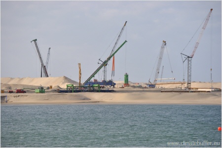
The port of Rotterdam extends some 40 kilometers along the Meuse-estuary to the North Sea. In the sixties the port area was enlarged with land-reclamation into the sea, about 4000 hectares called the Maasvlakte. At present the port is to be extended again as Maasvlakte 2 in order to secure the leading position of Rotterdam as the third-largest port after Shanghai and Singapore. On its completion, scheduled for 2033, the whole industrial area will cover 6000 hectares of the North Sea, the costs amounting to around 3 miljard Euros. The two areas, Maasvlakte 1 and 2 consist of a ring dyke, filled with sand from the sea.
The Maasvlakte 2 is part of the Rotterdam Mainport Development Project. Non-governmental organisations (NGO’s) are included in the planning process and especially Natuurmonumenten has a strong position. The project aims at a combination of measures of port-development and environmental spatial planning, with compensation measures such as the enhancement of the living environments of Rotterdam and surroundings.
Both Maasvlakte and Maasvlakte 2 are situated within the Natura 2000-site ‘Voordelta’, which extends along the coast of South Holland and Zeeland. Within the “Voordelta” there is the ecological compensation area too, with around 25.000 ha. Here large areas were closed for fisheries and recreation and a large scale monitoring will be carried out. A second but smaller compensation area is situated north of Maasvlakte on the other side of the ‘Nieuwe Waterweg’.
South of the port are the nature reserves ‘Green Beach’, Slikken van Voornes Duin. These contain valuable marshes, dunes and coastal flats as well as Marine Protected Areas.
Maaslvakte 2 - The new Port of Rotterdam
At the Maasvlakte, a large area of land is being reclaimed for industrial port expansion, called the Maasvlakte 2. Both the Maasvlakte and the Maasvlakte 2 are part of the Rotterdam Port and lie within the Natura 2000-site called ‘Voordelta’. Due to this expansion and the pollution created by an increase of activities, the ‘Voordelta’ and surrounding nature reserves may be negatively affected. In compensation for the destruction of part of the Natura 2000 site ‘Voordelta’ a 25,000ha seabed protection area has been set up, for birds, seals and a shallow seabed habitat. There is also a 35ha new dune area near Ter Heijde called ‘sand motor’ (see day three). Natuurmonumenten has been very influential in negotiating this compensation. Their priority was control on fishing in the existing site, rather than creating new sites. The development proposals were rejected in the courts after 10 years of negotiation, and in 2008 Natuurmonumenten persuaded the Port Authority that a Mutual Gains Approach (MGA) (= Consensus Building) was needed if the proposal was to go forward. Now, stakeholders meetings take place at least annually.
Maasvlakte 2 - a new port for Rotterdam
Voornes Duin
One of the surrounding nature reserves affected by the realization of Maasvlakte 2 is Voornes Duin. The Voornes Duin represents one of the most important dune areas in Eastern Europe, in terms of species richness, with an alternation of dunes, woods, wetlands and forests. It measures circa 860 ha and is one of Natuurmonumenten’s oldest reserves (1907) In 1907 it was open yellow dune. Now only 10% is open, due to: (1.) decline in rabbits; (2.) the port development (present and 1960’s) and the Haringvliet Sluice which have changed off-shore morphology and reduced the sand supply and the saline influence an (3.) nutrient enrichment, causing rapid scrub growth.
More than 100ha of scrub clearance is needed to achieve Natuurmonumenten’s aim for 40% open dune area. Problems are found in the emissions of pollution from Maasvlakte 2, part of Rotterdam Port, which result from more traffic, new industry and air transportation. This has a negative impact on the lean ground, especially nitrogen as a fertilizer. The nutrient enrichment issue could in theory stop the port development, so discussions on compensation are current.
The Voornes Duin is part of the Climate Buffer project, as one of the 19 sites in the Netherlands. The building of Maasvlakte into the North Sea has caused a change of the current situation, which impacts the coastal morphology. To mitigate this sand has been imported to create new artificial embryo and yellow dune, the natural ones having long since rolled inland and become scrub covered, leaving a clay beach. Clay was dug out and deposited further down the beach, and new sand was brought in, dredged from 6 kilometers offshore. This was established in 2009 and is part of a larger site for sand addition (17 hectares of a total of 34 hectares). Cost are €800,000, of a total of €40 – 50million over the whole site, met by provincial and national government. Marram has been planted to stabilize the sand pro temps. It is expected that this sand is to be blown away in 60 years, this is the time-span of the project.
At this pilot site for the Climate Buffer project, a large quantity of sand was imported some years ago to create new artificial embryo and yellow dunes. Now, re-vegetation techniques are used to restore the dune habitat and limit the erosion of the beach.
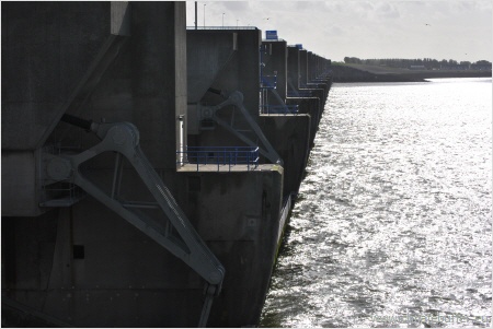
Haringvliet Sluices
In the afternoon the Haringvliet Sluices were visited. These sluices are part of the complex of the Delta Works and defend the river estuary against sea flooding. The decision has recently been made to allow the partial opening of the sluices to allow some seawater ingress into the estuary, benefiting biodiversity and migrating fish in particular. The former coastline of about 355 km was reduced by the Delta Works to about 60 km. Depending on the individual situation of the sluices, the brackish character of the landside water body decreases more and more.
As a result the tidal range was reduced from formerly 2 meter to 20-70 centimeter and the brackish character gradually turned into a freshwater situation. Because of this, watercourses silted up and the water storage capacity of the whole area decreased. With the Haringvliet sluices, the contact between river and sea was interrupted in one direction: the river water can be led to the sea. On the other hand the tide has no access into the Delta. The opening of the Haringvliet sluices is the condition forBarrier-free migration route of migratory fish-species,The return of the tidal influence into the delta and
The restoration of the brackish character in the Rhine-/Meuse-Delta
The opening of the sluices was discussed for 12 years and confirmed repeatedly by the government. Because of the resistance offered by other major stakeholders, the opening has been delayed a number of times. Reasons: fears of salinization of drinking-water wells and arable land in the Delta as well as increasing costs. Measures were taken to guarantee alternative ways to access fresh water supplies.
Currently, the major project, Room for the Rivers, managed by Staatsbosbeheer (State Forestry) is facilitating the restoration of the ecosystem and returning the room for the river by flooding grassland polders and turning them back into wetlands.
Haringvliet Sluice
Photo: Ralf Schulte (NABU)
The project started in 2010 and was finished in 2012.