Military Road
General Description
The A3055 Military Road is situated on the south western coast of the island and links Freshwater Bay in the west with Chale in the east. The original road was constructed as part of a defence network in about 1860 and came into public use as a highway in 1936.
This area of coastline is constantly changing. The sedimentary nature of the rocks and effects of the sea have had a dramatic impact on the land and man-made features in this area. A number of coastal properties, together with many hectares of farmland and amenities, have been lost over a number of years. The ongoing erosion has also had an impact on the Military road and has had to be moved further inland on several occasions.
In the mid 1980s, the Isle of Wight Council sought to divert the road inland at Afton Down so as to avoid an area of deep seated cracking and potential slippage. In 1985, a plan was submitted proposing the excavation of a new cutting further up-slope through the downland owned by the National Trust. The downland is of international environmental significance and the National Trust was not prepared to sell its land and opposed the scheme at the public inquiry. The Inspector considered the proposal and recommended that the scheme should not go ahead.
In 2000, the council subsequently commissioned engineering / geological consultants to review the situation and as a result of a report stabilised a section of the road on piles and realigned sections of the road.
More recent slipages have put the road under threat in a number of other places and the road is now down to one carriage way controlled with traffic lights.
The challenge is to plan a long term partnership strategy for providing access for recreation and enjoyment to this important coastline for when the road eventual disapears.
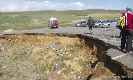
Erosion of the Military Road
Photo: Marthe Olthof
The project started in 2010 and was finished in 2012.